Drone Roof Inspection in Greenville, TX
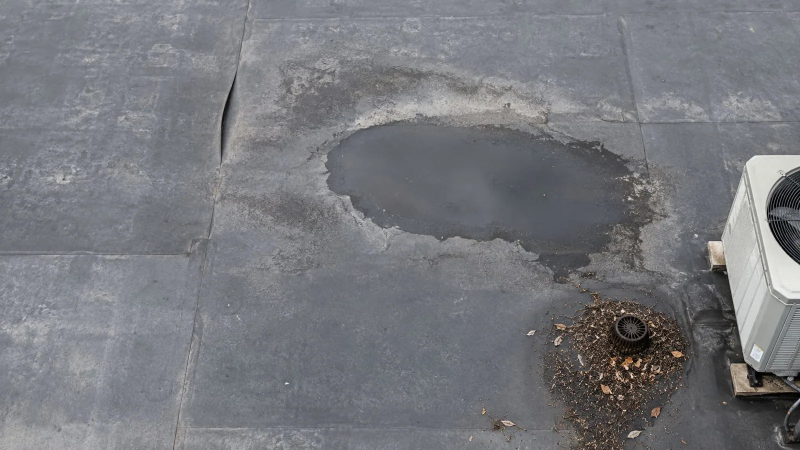
A pond sits in the middle of a plant roof two days after rain. From the ground you never see it. On foot you walk right through it. From the air it shows as a dark stain, and so do the clogged drain feeding it, the debris piles and the missing caps.
A drone roof inspection in Greenville, TX can give an aerial first look at a large or hard-to-reach roof. It does not replace a walk. The images help us identify areas that may need closer attention on foot.
When does a drone beat a ladder?
Whenever the roof is big, tall or fragile. A drone can document roof areas that are difficult to view from grade. Flight time and coverage depend on roof size, access, weather and airspace.
Some roofs should not take foot traffic at all. Brittle membranes, rusted decks, skylight fields and roofs that took hail or fire damage can be unsafe to walk. A drone gives us a first read without putting a person on a surface that might give way.
After a storm, aerial screening can help prioritize buildings for a hands-on inspection. The number of sites covered depends on access, flight conditions and airspace.
What does the drone actually see?
A planned flight can produce aerial images of seams, flashing, drains, edge metal and equipment. When the capture and processing support it, we arrange the images on a roof map so individual details and broader patterns can be reviewed.
If thermal imaging is included, temperature patterns can suggest areas for further testing. Results depend on timing, sun and roof assembly, so we confirm any suspected moisture with an infrared and core-cut moisture survey before scoping repairs.
We look for what the camera is good at finding: clogged drains, debris piles, torn or lifted membrane, missing coping, open flashing and signs of old repairs failing. Everything is dated and tied to its location on the roof.
What can a drone not tell me?
It cannot feel a roof. It cannot press a thumb into a soft spot, probe a seam, pull a fastener or cut a core. Hail bruising is a good example. From the air it can look like nothing, and on the roof it is a spongy dent.
That is why we pair the flight with a hands-on commercial roof inspection wherever the findings call for it. The drone points. The crew confirms.
Weather also limits flights. High wind, rain and low light shut us down. We pick a window with clear skies and calm air, so the images are sharp and the flight is safe. If conditions are poor, we reschedule instead of forcing a bad flight.
Aerial images do not show whether insulation is wet below an intact membrane, whether a seam is bonded through its full width, or whether a deck has lost strength. They also cannot replace a close look at a drain, termination bar or fastener. A responsible survey labels those limits and marks the locations that need hands-on confirmation. Before launch, the operator should agree on the flight boundary, occupied areas, overhead hazards, weather limit and image-delivery format with the property contact. Afterward, the roof map should connect each image to an area the crew can safely revisit. That combination makes the flight a screening tool for planning access, not a substitute for diagnosis.
What do I get after the flight?
A set of annotated images, a roof map with findings marked, and a short written summary of what we saw and what we recommend. You can forward it to an owner, a lender or an adjuster without reformatting.
The file also works as a baseline. Fly the same roof after the next storm and compare. Changes between flights show new damage, and dated images make a stronger record when you need to show an insurer what a storm did. That before-and-after record is the backbone of a roof insurance claim.
The images can be filed with written roof condition reports, giving an owner with several buildings a dated record to use when setting inspection priorities.
What does a drone survey cost and how long does it take?
Cost follows the size of the roof, the detail you want and whether thermal imaging is included. The flight itself is quick. Most of the time goes into planning the pattern, checking site and airspace conditions, and processing the images into a usable map.
Cost depends on roof area, access, image detail and any thermal work. Compare the flight scope with the labor and coverage needed for a walking survey; the better fit depends on the property.
Airspace is part of the plan. Majors Field, the city airport, sits about four nautical miles southeast of downtown Greenville, so flights near the airfield and its approaches get an airspace check before the drone leaves the case. We never launch without it.
Which Greenville roofs gain the most from a drone?
The big ones. Orbis operates a roughly 1.03-million-square-foot building in Greenville. For a large roof, compare drone coverage and a walking inspection after measuring roof area and confirming access. The SH 66 and US 380 industrial area is one part of Greenville’s industrial building stock. Partsmaster operates a 123,200-square-foot warehouse in the city’s industrial area, and Fritz Industries operates a Greenville plant. For a large manufacturing plant roof, compare aerial coverage with a walking survey after measuring roof area and confirming access.
After a hail event, aerial images can help screen roof surfaces; a close inspection is still needed to confirm damage and scope. The June 2019 storm brought baseball-sized hail to Greenville, and North Texas spring storms can reach softball size. Hail damage repair on a big roof often begins with a flight.
Hospitals and school complexes with several roof levels can benefit too. Fewer people on the roof means fewer disruptions below.
For large industrial roofs, divide the image set by building and elevation before comparing conditions. A short caption should say what is visible, where it is, and whether a close inspection is recommended. That keeps screening findings separate from confirmed defects.
Commercial Roofing Questions
Is a drone inspection enough, or do I still need someone on the roof?
For a first look or a quick storm check, a drone is often enough. For a repair decision, a replacement bid or a moisture question, you still want a hands-on walk or a moisture survey. We recommend starting with the flight on large roofs, then sending the crew only to the spots that need touch.
Can you fly over an occupied building?
Occupied sites need a flight plan that accounts for access, people below and facility rules. We coordinate launch location, timing and any restricted areas with the site contact before the survey.
How soon after a storm should the roof be flown?
As soon as conditions allow. Fresh damage is easier to read and easier to tie to a specific event. Waiting weeks lets other weather and debris cloud the picture. Call us after any hail or high wind and we will fit you into the first clear window.
What if the drone finds nothing wrong?
Then you have a dated image set showing what was visible from the flight that day; it cannot establish hidden conditions the camera could not show. It also sets a baseline for the next flight. We still tell you what to watch, since some conditions, like early hail bruising, do not show clearly from the air.
Can drone images go to my insurance adjuster?
Yes. Aerial images can document visible conditions and help locate findings for review. We label what the flight shows, while the adjuster and policy determine coverage and claim handling.